How a detection works
The detector reads a color test out of an aerial photo, then a shape and distance check against the property line. Below: a real photo with what it found marked, then a color test you can try yourself.
A real photo, not a mockup
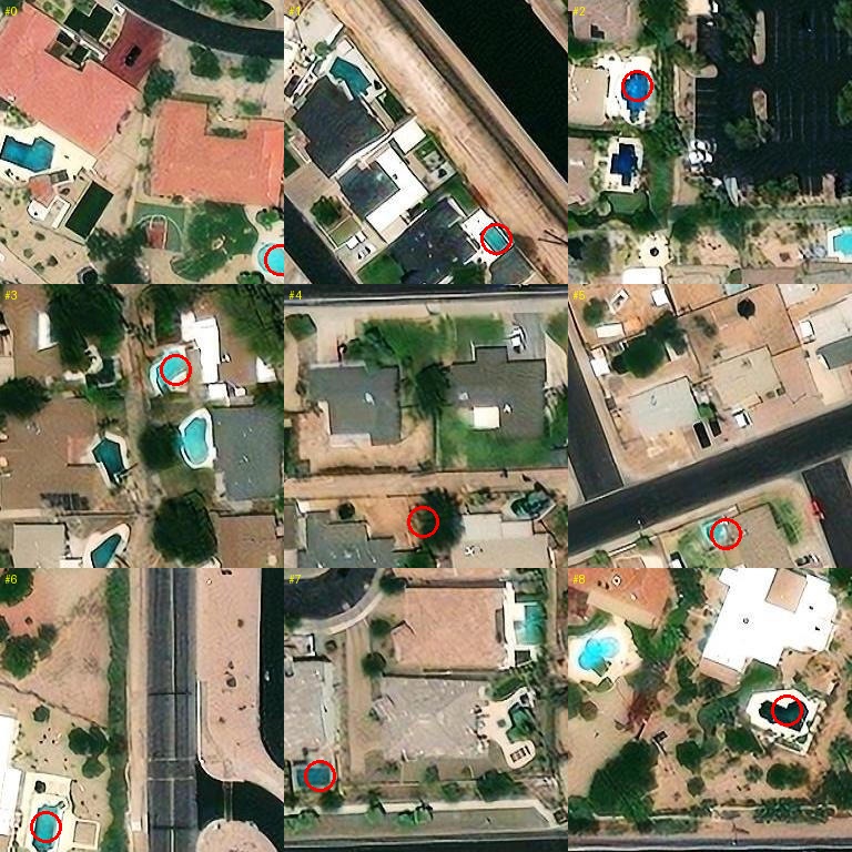
A public aerial photo, with nine of the detector's own flags circled in red. Most land on a real pool. One (bottom middle) lands on bare ground next to the pool it should have circled — a miss, kept in on purpose. Source: USDA NAIP aerial imagery via the USGS National Map, Maricopa County, AZ — public domain, no fee, no login. Full source note below.
Try the color test yourself
This part is a simplified, simulated scene, not a real photo — it runs the same kind of color test the real detector runs, drag the slider and see for yourself that no setting finds every pool without also flagging something that isn't one.
The exact rule the real detector runs (method, for the curious)
mean_b > mean_r AND mean_b > 80 AND mean_ndwi > 0.15 AND 15 ≤ area_sqm ≤ 80 AND aspect < 2
The real rule also checks shape and size, not just color, which is why the shipped detector's real numbers — 38 pools found per 100, well under 1 wrong flag per 100 — don't match this simplified toy grid exactly. The toy grid exists to show the shape of the tradeoff, not to reproduce the exact numbers.
Photo: USDA NAIP aerial imagery via the USGS National Map ImageServer (imagery.nationalmap.gov), Maricopa County, AZ. US federal work, public domain under 17 U.S.C. §105. Detection formula and real detector numbers: measured on one Maricopa County, AZ aerial pass, 2026-07-26, 5,186 parcels with a recorded pool vs 17,661 without.